Northern Pakistan itinerary
- Viajeros Perrunos

- Feb 9
- 32 min read
Updated: Feb 17
Not many people dare to visit Pakistan and discover this incredible gem. Its triple mountains in the north –Himalaya, Karakoram and Hindu Kush–, bordering countries as diverse as India, China, Afghanistan (and almost Tajikistan), are an ode to nature. Rivers, lakes, glaciers, kilometre-long suspension bridges, diverse forests and even frozen deserts await here, which can be reached after epic journeys on winding roads. Some of them have historical importance on the Silk Road between the Indian subcontinent and Central Asia, such as the Karakoram Highway.

The south, on the other hand, is a very different world: hot, chaotic, a cousin of India, and with a great history behind it, that of the Indus Valley civilization.
But there is something even more wonderful than all that, at least for those of us who, after so many years of travelling, have understood the meaning of it all: the Pakistani people. Punjabis, Sindis, Pashtuns, Chitralis, Sina, Kashmiris, Baluches… all of them ethnic groups of the most varied kind but with one thing in common: their generosity and unparalleled hospitality. Getting to know each of these people is more than enough reason to travel the country from end to end (we were there for more than half a year and it didn’t seem long at all), and that is why I am going to recommend a detailed itinerary for the north (like the one we did), from Islamabad up, with a recommended time of three months (if you have more time, even better!) and another shorter one for the south, from Lahore and Punjab down. This second one is described in the post SOUTHERN PAKISTAN ITINERARY.

Note 1. Itineraries adapted from our trips. The first time we entered from Iran (Taftan Border) and the second time from India (Wagah Border).
Note 2. The weather is very variable depending on the time of year. The south is very hot in summer and is best explored between autumn and winter. The north is cold from November to March and is best explored between spring and autumn.
RECOMMENDED TIME: 90 – 100 DAYS
ISLAMABAD

Pakistan's capital is not a must-see by any means. However, some people may land here and many travelers have to stop to do some paperwork (fixing a visa to go to India, for example) and it has its interesting things. If you spend several weeks or months in the wild north or the busy south, you will welcome this modern, clean and green city with open arms.
See and do
Faisal Mosque. This 21st-century mosque that looks like a spaceship is currently the fifth largest in the world.
Margalla Hills. The hills that guard Islamabad on its northern side offer visitors splendid views of the city. Along the way you will see monkeys and many plants and flowers.
More westernised food. In many places in Pakistan the menu is very simple and local. Islamabad has a huge offer, including pasta dishes, pizza, hamburgers, ice cream, cakes, etc.
Taxila. Archaeological site that houses the ruins of the city of Gandhara and the Taksashila school, which was an important center of Hindu and Buddhist teaching between the 5th century BC and the 2nd century AD..
Accommodation
I recommend the Youth Hostel, not only for its price and atmosphere, but also because it is close to the Diplomatic Enclave (the embassy area), which will make things easier if you go to India afterwards. If you are traveling with a dog, you can try camping in the garden, although the place is not dog-friendly. Another option is Couchsurfing, which works quite well in the country.
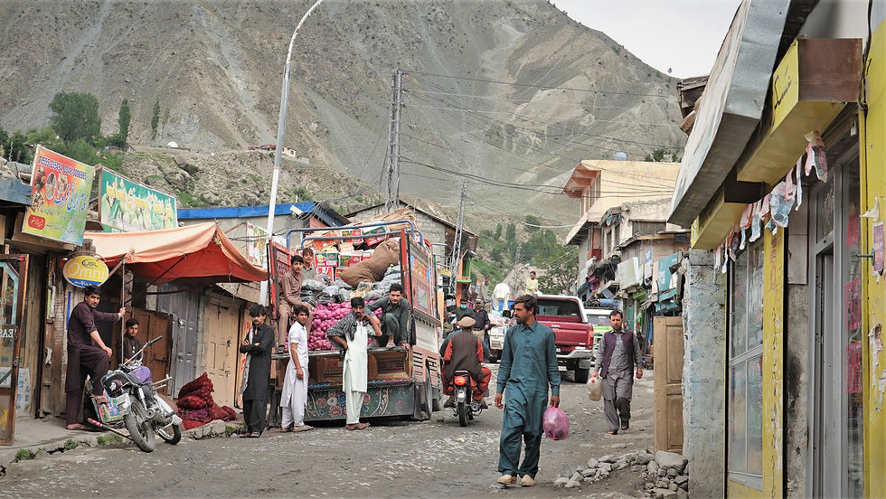
PESHAWAR

“Peshawar es una de esas ciudades que rebosa historia. Fundada hacia el año 140 d. C. por Kanishka (rey del Imperio kushán), ha pasado por muchas etapas, cambiando el budismo por el islam por el camino y estableciéndose como uno de los enclaves principales de la antigua Ruta de la Seda. No solo servía como parada y lugar de intercambio de bienes, sino también como cruce de culturas de Oriente Medio, Asia Central y China. A día de hoy la mayoría de la población es pastún y altamente tradicional. Con el pasado reciente de la guerra en la vecina Afganistán y su papel como centro de refugiados y espías, se vive todavía cierta tensión en el nombre de radicales religiosos que no aceptan otras religiones o incluso ramas del islam diferentes…”. Fragment from my book El Pekín Express Canino.
There is no other city like it. Just walking through its streets will make you feel that it was worth coming, with its historic houses, markets and people dressed in traditional clothes. The most important mosque is the Mahabat Mosque, from the Mughal era, and the bazaar in the old town is also a must-see. There are also things to do around the city.
Around Peshawar
Khyber Pass. This is a natural corridor connecting Pakistan and Afghanistan, which has been a key trade route for centuries. It is a scenic road through a bare, rocky landscape. If you are going to Afghanistan by land, it is currently the only open border.
Kabul river. This river runs along the northern edge of Peshawar and is ideal for cooling off after a hot day. You may see people and animals bathing.

Note. If you like dogs and want to discover a beautiful project, you can visit the Lucky Animal Protection Shelter, near Charsadda. When I have time, I will write an article about this foundation run by Zeba Masooud. If you are interested in going to see the project, you can write to them on Instagram: @lapskpk
EXPLORING DIR (ALTERNATIVE 1)

The route from Peshawar to Chitral passes through the districts of Lower and Upper Dir, a very little explored and conservative territory. You will pass through hilly lands and through towns where only men seem to exist. Despite this shock that it may cause any traveler, the people of Dir are some of the most hospitable in Pakistan (and therefore on the planet). In the random villages that we stopped at, thanks to the vehicles that took us hitchhiking and the military pickups, they invited us to eat, sleep and went out of their way to help. If you are a woman, you will be “lucky” enough to meet the women of the families and talk to them. Some recommended places on this route:
Mardan. Historic city with several Buddhist monastic complexes nearby. The most important is Takht-i-Bahi.
Timergara. This small town lies on the banks of the Panjkora River. It is not particularly beautiful in itself, but rather because of its location between the river and the surrounding mountains.
Dir. The district capital, also highly traditional.
Accommodation
I was lucky enough to meet families who hosted us in their homes, because there isn't much infrastructure.
SWAT VALLEY AND KALAM FOREST (ALTERNATIVE 2)

“El plan era seguir para el norte y visitar el Mahodand Lake. Para ello había que conducir por una zona increíblemente bella, en paralelo al Ushu river, que nace en algún glaciar entre los Himalayas de Pakistán… o quizá China, Afganistán o Tayikistán, who knows. Porque en este peculiar rincón del planeta hay tintes de esas tierras… Vimos templos con arquitectura más propia del Tíbet o del budismo. Bueno templos y pueblos auténticos. Los habitantes de este valle aislado y poco transitado por el que apenas circulan camiones cargados de materiales y provisiones, salían felices a saludarnos. En especial los niños y adolescentes, que corrían detrás de La Garrapata y se peleaban por asomarse a las ventanillas. Sus caras de incredulidad por tener tres visitantes foráneos con dos perras domésticas me hicieron reflexionar Y eso que nosotros íbamos con las bocas abiertas. Con todo, poblaciones… y paisaje”. El Pekín Express Canino.
The road from Swat to Kalam is a marvel, between breathtaking peaks and following the majestic Swat River. As you climb up this beautiful valley you discover towns that invite the traveler to stop for a meal or a stroll. Other attractions that this route offers are the dozens of suspension bridges that cross the Swat River and the many viewpoints that follow one another. The route becomes more and more beautiful, until you reach Kalam, a beautiful and traditional town. Here the streets are full of men dressed in their typical regional blankets and hats.

A few kilometres away is the Ushu Forest or Kalam Forest Reserve, a beautiful place to camp for a few nights and explore the very special valley formed by the Ushu River. If the conditions of the dirt road allow it, you may reach a Pakistani hidden treasure called Mahodand Lake.
Accommodation
We camped in an open field at the entrance to Torkwal and also in the Kalam Forest.
Note: Near Mingora is The Buddha of Swat, an impressive sculpture of a Buddha carved into a rock face that symbolises the legacy of the area's Buddhist past. The Taliban destroyed it in 2007, but the Pakistani government later restored it. It is well worth a visit and does not even require a detour.

KUMRAT VALLEY

You can't miss this wild valley of stratospheric beauty, even if it means a long detour (several days each way if you come from Dir). Not so much because of the distance as because of the road conditions. You go uphill and enter into increasingly remote (and beautiful) areas, following the course of the Panjkora River, until you reach the mountain village of Thal. From here, a dirt track starts to the heart of Kumrat, which can only be reached by 4x4 vehicle, as you cross the river several times.
In this valley you can see forests, waterfalls, lakes, flower fields, snowfields, goats, birds and other animals of the region (watch out for the snow leopard!). We did a full-day trek, but there is the possibility of going much further and even reaching Laspur Valley (see later in this post), on a route that seems legendary through those remote Hindu Kush mountains. Warning: it takes about five days, you will cross glaciers and it can only be done between June and September.
Note. Kundol Lake is the most popular lake in the area. It is close to Thal. We did not visit it because it was closed at the beginning of May when we passed by.
Accommodation
As of 2021, there was some kind of hotel and they were building several cabins, which indicates that they are going to exploit it for tourism. If you have a tent, don't hesitate to camp.
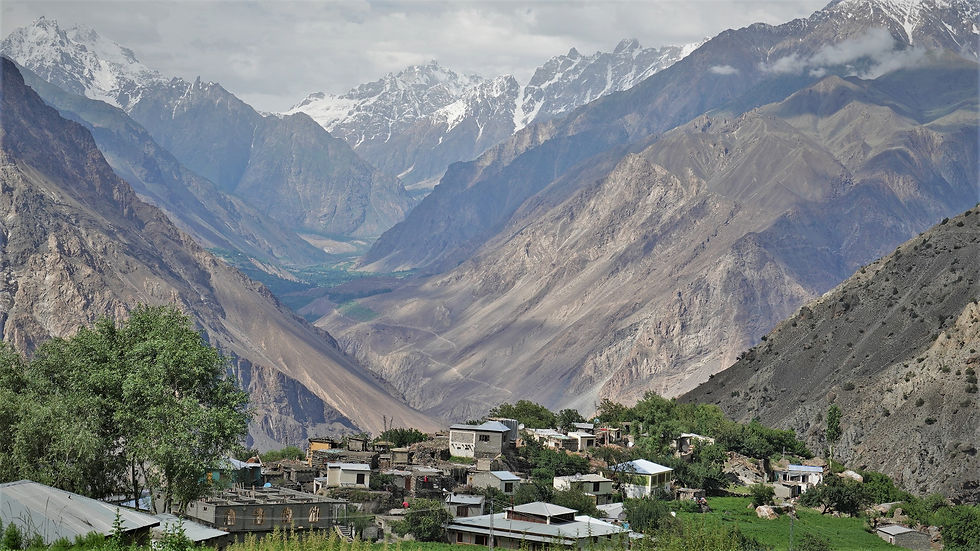
CHITRAL

“Fue varios días más tarde que me enteré de que me estaba codeando y sentando a la mesa (o al mantel en el suelo) con la realeza. Este hombre de aspecto sencillo resultó tener sangre azul. Ni más ni menos que el nieto del que fuera último rey del Chitral Kingdom (1700-1969), y sus siete hijos por tanto príncipes y princesas todos ellos”. El Pekín Express Canino.
Chitral is a natural and, above all, cultural gift. In this particular corner close to Afghanistan, people who were practically isolated until not long ago coexist, which is why they preserve their traditions and ways of life. Their own languages, their own music and dances, their own dress code… and even their own sports. One of the symbols of Chitral is polo. Or rather, free style polo. Throughout the districts of Lower and Upper Chitral (see below), as well as in Gilgit (see also below) men get on their horses and play this ancient sport. All this, added to the fact that until just a few decades ago Chitral was an independent territory, the Kingdom of Chitral, explains the Chitral pride. My recommendation is that if you are lucky enough to come with time, you stay a few weeks in the area to soak up its magic. Here I am going to describe the capital and a place that I have a special affection for because we were adopted/kidnapped by a wonderful family member.
Ayun and Dalgram. Most visitors pass through these towns without stopping on their way to the neighbouring Kalashi valleys (described below). However, it is a highly recommended stop on the itinerary. Here I met my dear Hilal while strolling down a dirt road, he invited me to tea at his home… and that turned into a month with his family. Best of all, this wonderful house and its wonderful gardens are proudly open to the public. Anyone who goes will be welcomed and, surely, treated to the fruits of the season: walnuts, cherries, apricots, apples… Aside from Hilal’s house, the main activities in the Ayun Valley consist of wandering around the bazaar, chatting with the locals, drinking chai and exploring the beautiful surroundings. You can walk down to the Kunar River or climb up the mountainside for dreamy views (pictured above).

Chitral. A charming little town on the banks of the Kunar River. Its mountains, lively bazaar and historic monuments – the Chitral Fort and the Shahi Masjid mosque in the foreground – captivate travellers. You can also climb to a viewing point, such as the one at the entrance to the Chitral Gol National Park (described later).
Accommodation
There are a handful of options in Chitral. I camped at the Pamir Riverside Inn Hotel, although dogs are not allowed. There are several hotels in Ayun. As always, if you have a tent you can pitch it almost anywhere you want.
KALASH VALLEYS

“Los kalashi son un pueblo fascinante en riesgo de extinción sobre el que había leído antes de ir a Pakistán. Viven en tres valles remotos y contiguos rozando la frontera con Afganistán. Hay varias teorías sobre el origen de este singular grupo étnico. La más exótica y aplaudida por ellos mismos es que son los descendientes de Alejandro Magno y sus tropas. En cualquier caso, su cultura es única y fascinante, muy diferente a la de sus vecinos musulmanes, con quienes conviven en paz, aunque se quejan amargamente de que los están absorbiendo y conquistando sus tierras. Los cerca de 4000 kalashis –menos numerosos año tras año por conversión al islam– tienen una serie de particularidades a nivel de rituales, así como en su forma de vida y sociedad. Una de las más características es que creen y rezan a unos dioses muy distintos a Allah: las nubes, los truenos, el sol, las montañas… Seguramente lo más remarcable del pueblo kalashi son los vestidos coloridos y llenos de adornos de las mujeres. En estos tres valles, ellas, lejos de ir tapadas como en gran parte de Pakistán, se exhiben. Esto se acentúa todavía más en los cuatro grandes festivales kalashis, celebrados en cada estación del año”. El Pekín Express Canino.
There are three valleys: Rumbur, Bumburet and Birir. If you have time, go to all three, but if you can only visit one, it doesn't matter, because you'll get it right anyway. In all of them you can walk among centuries-old walnut trees, cool off in the river, pick apricots, walnuts or seasonal fruits... and, above all, chat with the Kalashis and Chitralis in the street and in their terraced houses. They will show you their hospitality and their cultural treasures, such as their crafts and their private buildings. Among others, the beshalini, where women go every time they have their period, and the cemeteries, where the dead are partially buried, stand out. In the Bumburet cemetery, there is the tomb of Jordi Magraner, a (crypto)zoologist and Yeti seeker or, as the Chitralis know him, the barmanu.

This is one of the episodes that I describe in more detail in El Pekín Express Canino, because, as I mentioned, we spent about a month and a half in these lands and lived with a very special family. Hilal himself met Jordi in the 90s.
What I do recommend is to do your best to arrive during one of the seasonal festivals:
“Chilam Joshi” (Spring)
“Uchal” (Summer)
“Choimus” (Winter)

To keep in mind for your visit: as you go up the valleys the proportion of Kalashis increases and that of Chitralis decreases. At the end of each valley, there is also an even smaller ethnic group, who come from Afghanistan: the Shakhanandeh. Rumbur and Bumburet are reached by a spectacular road, which then splits off, from Ayun, while the track to Birir is separate. The valleys are connected by mountain routes, for the more adventurous. Rumbur can also be reached from Chitral Gol National Park.
EXTRA Note: Chitral Gol National Park. If you are passionate about trekking, you cannot miss this excursion. Because of the powerful and wild nature and also because these mountains of stratospheric beauty were where Jordi Magraner believed the Yeti lived. It connects with the end of the Rumbur Valley. Warning: the hike lasts about three or four days, is not well marked and is very demanding.

Accommodation
The most touristic valley, and therefore with the most overnight accommodation options, is Bumburet. There are a handful of guest houses and campsites there. Rumbur also has some infrastructure. However, if you have a tent, it is very easy to find a place to camp freely. If you are not “kidnapped” by a family, as often happens in these lands.
BUNI, SONOGHUR AND MASTUJ: ENTERING UPPER CHITRAL

“… desde que aterrizamos en Buni vi muchas más mujeres y niñas por la calle, solamente con un velo en la cabeza o incluso sin ir tapadas en absoluto, y con frecuencia hablando en la calle con vecinos hombres… Poco tiempo después me enteraría de que aquí muchas familias son ismailis, una rama minoritaria de la religión musulmana. Buni es un lugar de transición en realidad: fifty suníes y fifty ismailis. Mientras lo que queda al oeste es suní, las tierras al este de Upper Chitral, así como partes de Gilgit, son mayoritariamente ismailis… Los ismailis son solo unos pocos millones dentro del Mundo Islámico –la mayoría viven entre Pakistán, Afganistán y Tayikistán– y se caracterizan, entre otras cosas, por la educación universal para toda la población y porque, a diferencia del resto de sus hermanos musulmanes, rezan todos juntos –hombres y mujeres– en sus templos, llamados jamatkhanas y no mezquitas… Además, la mayoría de matrimonios son por amor y no organizados por las familias. Todo ello apunta a una mayor libertad y derechos para ellas, que pueden estudiar e incluso ir a la universidad, rezar dentro de las jamatkhanas si así lo desean y tener más voz y voto en la elección de su futuro marido”. El Pekín Express Canino.
Upper Chitral is one of my favourite places in Pakistan, both culturally and naturally. Here Sunnis and Ismailis live together peacefully, they are extremely charming and, best of all, there is more openness and freedom for women. After weeks in Dir and Chitral with hardly any contact with them, I felt immense relief when I arrived here.

The Hindu Kush mountains in this northern corner that borders the mythical Wakhan Corridor are particularly mind-blowing. I will briefly describe the main towns and what the traveler can do.
Buni. Towering over the Kunar River and surrounded by huge peaks such as Buni Zom (6550m) and Tirich Mir (7700m), Buni is one of those destinations where any adventurer would want to spend some time. The range of possible excursions is very wide, from a walk uphill making your way between farms to the water channel that irrigates the town and the surrounding areas… to climbing some of the mountains. Qaqlasht stands out above the rest. However, the best activity will be to make local friends who, in addition to their valuable friendship, will teach you about their culture. In the almost two weeks I spent here I attended a wedding, several musical events, a polo match/training and, of course, I was the guest of honor in a handful of homes. As in all of Chitral, the gardens are very well kept, full of flowers and fruit trees.

Sonoghur. Located at the foot of a glacier, this cute village of charming people is definitely worth a visit. It also has a “polo ground”, with the glacier as a backdrop. No more, no less.
Mastuj. Another interesting town, nestled at the confluence of several rivers. From the top of that hillside that crowns both valleys with rivers between mountains, one feels the immensity of nature. From Mastuj there are two roads: one towards the lands of Boroghol and another towards Laspur. I couldn't do the first one (it was just the Taliban expansion in the summer of 2021 and they wouldn't let us go to that area), but from what I read and what I was told, it must be really amazing (described below). I describe Laspur Valley in the next section.
EXTRA NOTE: The stretches between Buni and Sonoghur and between Sonoghur and Mastuj can (and should!) be done on foot. While the road runs along the river, there are dirt roads parallel to it on the other side. On these walks, which are about 20 km long, you pass through villages irrigated by the canal/ditch with their crops, bare mountains, small forests… and you cross the river on bridges straight out of Indiana Jones.

Accommodation
In Buni I highly recommend The Village White Rock, a guest house run by my dear Anwar Khan. It is one of my favourite accommodations in all of Pakistan, because of Anwar himself and the great vibe. You can sleep in a room or camp in the garden. In Sonoghur I don't think there is a guest house (we were hosted by a family) and in Mastuj we camped on the grounds of a guest house (there are a few).
LASPUR VALLEY AND SHANDUR PASS

“El paisaje salvaje, los pueblitos encajonados al fondo del valle, los picos nevados, los pastores y sus cabras. Me parece fascinante que viva gente en lugares tan remotos y puros. ¿Cómo será un invierno ahí, aislado y desconectado de todo? Y llegamos a Laspur. El último pueblo del valle. O el primero, según se mire. Luego hay que subir una montaña, cruzar el Shandur Pass, y bajar a otro valle que ya es parte del distrito de Ghizer y de la provincia o territorio independiente de Gilgit-Baltistán”. El Pekín Express Canino.
More spectacular mountains. The route from Mastuj to Sor Laspur is about 35 km, which gradually gains in beauty. Any village you stop in will surprise you, but Laspur, the last and most isolated, is perhaps the most charming. Here begins the steep and impressive climb to the Shandur Pass, which divides Chitral from Gilgit. After leaving behind snowfields and pastures inhabited by yaks (the giant cows of the Himalayas) you will reach this mountain pass famous for being the venue of the Shandur Polo Festival. On this polo field, the highest on the planet (3,800 meters above sea level), the final between the great rivals is played every year in mid-July. A Chitral vs Gilgit polo match is the equivalent of Madrid vs Barça in football, an event that brings together thousands of people who come excitedly to support their favorite teams and then celebrate, whether they win or lose, with traditional music and dances. If you are not there on those dates, don't worry, because the visit is worth it in itself (and the route that follows even more so). On this green plateau, home to hundreds of cows, lies Shandur Lake, a mirror of water surrounded by snowy peaks just a few metres from the polo ground. If you have climbed on foot, you will regain your energy immediately. There are also a couple of stalls where you can have tea with biscuits or a plate of hot food.

After the lake, the descent begins towards Ghizer Valley. This first stretch of the formidable and unfairly little-visited district of Ghizer, the gateway to Gilgit, is an oasis of rivers and flowering meadows. I guarantee you will feel jealous of the lucky cows and yaks that inhabit it.

Once below, you can embark on an excursion before traveling through the Ghizer Valley (described below), following the course of the Ghizer River against the current: Baha Chhat Lake (or Khukhush Lake).
Accommodation
There is not much tourist infrastructure in the area, but you can find some guest houses along the valley and if not, try asking at family homes. We stayed with a family for one night in a small village and another in a guest house at the end of Sor Laspur. It didn't have a name, but I think it's the only one (at least as of 2021). There is a small hotel at Shandur Pass. Those of you travelling with a tent are in luck, as it's amazing to sleep in these settings.
EXTRA NOTE: As I already described in the Kumrat Valley section, there is the possibility of joining Laspur with the Kumrat Valley by crossing the mountains in a trek that must be spectacular. Only for experienced people.
GHIZER VALLEY

“Llegamos al magnífico inicio del Ghizer Valley, donde se juntan los ríos Gilgit y Ghizer. Una de las praderas más bonitas que he visto nunca. Sobre esas hierbas estaba la mayor manada de yaks que jamás he visto y probablemente veré. Eran como un centenar, todos ahí pastando y bebiendo agua de las verdes tierras mojadas”. El Pekín Express Canino.
Of all the amazing valleys and roads in Pakistan, this valley and the road that runs through it may be my favorite. Following the Gilgit River you pass through several towns, all of them immersed in a Lord of the Rings-type landscape. That's the plan here, to drive through the valley and stop wherever you like.

Phander and its surroundings are particularly beautiful. After passing Barsat and Teru, which are more arid, you reach a stretch of the river where the waters flow very slowly, almost like a lake, forming meanders, pools and milky blue lakes. Terich and Phander are situated in this privileged location, with especially fertile and green lands for the cows to graze at ease. A paradise to enjoy a few days of rest: bathe in the frozen river, go to a nearby lake, eat... and climb a hill and contemplate everything from above. It may be tiring, but only in this way can you be aware of this valley nestled between two mountains and this river full of branches that crosses it.
Accommodation
There is a lovely guest house in Teru, Shandur Paradise. Phander has a wide range of options. In Gahkuch (the capital of Ghizer) there are also several options, such as Karim Guest House. Dogs are allowed! As usual, camping is very easy, as long as you don't get "kidnapped" by a local family... or by the police. This happened to us in Gahkuch and we ended up sleeping in the police station.
YASIN VALLEY

This is a branch within the Ghizer Valley, created by another river, the Yasin. This valley opens up at the height of the town of Gupis and only stops in its efforts when it comes face to face with the monstrous mountains that guard Darkut, the last and most special settlement. We are in the Pamir, that mythical mountain range dreamed of by so many travelers who want to discover Central Asia. Not only Kyrgyzstan and Tajikistan are its owners, this corner of Pakistan is too. It is not easy to get here, but it is a major adventure that is very much worth it. You will not regret spending a few days exploring the Yasin Valley. For its obvious beauty and also for, once again, other peoples who add to that endless cultural spectrum that this country treasures. The majority is Ismaili and you will see many women and girls with a simple veil or without covering themselves at all, walking down the street, shopping in stores or herding cattle.

Accommodation
In Yasin there is the Fort Hotel, a nice guest house where you will be very well received. You can sleep in a bed or camp for cheap prices. They serve breakfast. In Darkut there is no infrastructure, but you can camp or stay with a family.
EXTRA NOTE: Boroghol Valley. If Darkut is remote, this town and the valley it sits on are virtually isolated from everything, on the banks of the Wakhan Corridor in the Pamir Mountains. You can only get there by a dirt road from Mastuj, a journey that takes about 14 hours, or by walking through several mountain passes and glaciers from Darkut. As I have already mentioned, we were not able to go because it was just the Taliban expansion (summer 2021) and we were forbidden to go to that area. If you like trekking, try it, either on your own if you have experience, or with a local guide… or by 4x4 from Mastuj. The inhabitants of Boroghol have developed unique traditions. For example, they play yak polo: instead of horses they ride yaks. There is even a festival, the Yak Polo Festival. In addition, the trek itself to get there sounds like a good adventure.
THE KARAKORAM HIGHWAY (KKH)

“Durante horas y horas fuimos serpenteando por la KKH, elevados sobre ese valle de película, a contracorriente de ese escultor fluvial llamado Indus river, despacito pero sin pausa. El abismo estuvo presente en todo momento, a centímetros de nuestras ruedas. El río Indo devorando todo a su paso varios cientos de metros abajo. Esa carretera, por momentos camino para mulas, era un salto al vacío. Un paso en falso y “hasta nunqui Lucas”. El Pekín Express Canino.
The nickname THE EIGHT WONDER OF THE WORLD does justice to this “highway” that is at times an unpaved road strewn with rocks fallen from the sky. The road links Islamabad with the Khunjerab Pass, the border control between Pakistan and China. Beyond completing it or not, traveling it is an adventure for intrepid souls: nature in its purest form, history, mysteries… Any place is good for camping, such as its Martian plains, forests… and even police stations. Along the way there are a good handful of “highlights” where you can stop, including towns and movie-like locations. For example: Gilgit, Nanga Parbat, Rakaposhi, Karimabad, Attabad Lake, Passu, Borith Lake… In the following sections I will describe them.
GILGIT AND NALTER VALLEY

“La ruta de Nomal a Naltar Bala, además de preciosa escalando por el Naltar Valley, tuvo un ingrediente extra que ya viene siendo habitual en nuestro viaje: personas maravillosas… Dejamos atrás Nomal y enfilamos todo para arriba por una carretera de tierra. Otro río nos acompañaba a mano derecha. Y sin pedirlo, el conductor de una camioneta que iba montaña arriba –el primer vehículo de los pocos que pasaron– paró a nuestra vera para ofrecer un ride…. Al principio la nieve cubría apenas unos centímetros. Poco después era un paisaje enteramente blanco que como podríamos comprobar al bajar del vehículo en Naltar Bala cubría hasta más allá de las rodillas. La población, sus bosques y montañas circundantes estaban completamente cubiertas de nieve. Una preciosidad”. El Pekín Express Canino.
Gilgit. The capital is an attractive and interesting city to visit. I have no other recommendation than to stroll through its always lively streets, full of restaurants, tea shops and shops. The surroundings – mountains and river – are also wonderful and you only have to walk a few minutes from the centre to be in nature.

Nalter Valley (Naltar Bala). This is a nearby valley that few travelers ever visit. It cuts through a tributary of the Indus River and climbs hundreds of metres up to the top of a mountain. It can only be reached by a broken road that starts from the picturesque Nomal (a village that is also worth a visit) and passes only two villages: Nalter Paeen… and Naltar Bala, at the top. Despite the road conditions, there is a ski resort, but what interests most of us here is something else. There are forests, glacial lakes… and culture.
Accommodation
There are a handful of guest houses and campsites in the village. Wild camping is also possible.
TREKKING TO RAKAPOSHI BASECAMP

“… salimos hacia esa aventura de 7800 metros de altura. En otras palabras, la decimoséptima montaña más alta del planeta. Nosotros llegaríamos al campo base, a casi 4000 msnm después de dos jornadas de trekking superando unos 1500 metros de desnivel en total. A diferencia de Fairy Meadows y el Nanga Parbat, es una ruta muy poco popular (aún), pero igualmente bella. O más. La secuencia es parecida: primero subimos por una vertiente pelada, casi desértica, que fue seguramente lo más duro por lo empinado de la cuesta y por el calor sin sombras en las que refugiarse. Luego entramos en zona de bosques y ríos… La última parte es la más pronunciada y demandante, pero también la más bella: los picos alrededor forman un escenario maravilloso, y si miras hacia abajo ves lo que has dejado atrás y te invade el orgullo… Nos hicimos unos noodles a mitad de la subida final y llegamos a tope de power a la cima donde descansaba el glaciar. Sonia, Cocaí, Chai y yo estábamos solos ante el silencio sepulcral. Únicamente interrumpido de vez en cuando por el rugir de los pedazos de hielo que se desprendían y las pequeñas avalanchas. Estuvimos contemplando ese espectáculo un buen rato, sin hablar”. El Pekín Express Canino.
It all starts in Minapin. Anyone who comes to do this trek will spend the night in this pleasant village, either before to take a few days off and get mentally prepared, or afterwards to recover the energy invested in such a feat, or both. That was our case hehe. How many days do you need? Well, it depends on your fitness level, but I would say that three days is enough to do the round trip. It's amazing.

Accommodation
There are at least half a dozen guest houses in Minapin. I recommend the Osho Tang Guest House (if you have a dog you can only camp there). Good prices, the owner is very nice and the food they make is very good.
On the way to Rakaposhi, there are two spots where most hikers spend the night. Hakapun, almost at the end of the forest area, is a group of tepees and tents on top of an esplanade. In addition to being able to sleep in one of them, or in your own tent if you have one, they serve meals. The guys who run it are very nice and the prices are cheap for being at the end of the world (at least as of 2021). The other is at the end of the route, right next to the glacier, where there is a kind of improvised campsite. You can rent a tent or sleep in your own (for free). Of course, you can also camp along the way.
Note. Nagar district is not just about Rakaposhi. Less known than the popular neighbouring Hunza, Nagar has many treasures to discover. I dare you to venture into it!
ROAD TRIP AROUND HUNZA NAGAR

Probably the most spectacular stretch of the Karakoram Highway, surrounded by monstrous peaks and with many interesting places to visit. Here are some:
Karimabad, Altit and Baltit Fort. This is one of the most interesting towns in Hunza, located high up in the valley, with fabulous views of the mountain range and the surrounding landscape and a wide range of accommodation options. You can stay here for a few days to chat with locals, meet travelers, walk, eat... and visit some of its most special places. Highlights include Altit Fort and Baltit Fort, two fortresses over 1000 years old and UNESCO World Heritage Sites.
Attabad Lake. An emerald lake next to the Karakoram Highway. Personally, it bothers me a little that it has restaurants and businesses right on the lake, but you cannot deny nature's gift of its turquoise waters, even if you see it from the car.

Borith Lake and Hussaini Suspension Bridge. Just past the town of Gulmit are these two tourist attractions. Borith Lake is a beautiful lake surrounded by peaks where you can spend the day and even stay overnight, either with your tent or in a guest house (I think there were two as of 2021). The Hussaini Suspension Bridge is one of the longest suspension bridges in the world, levitating 30 meters above the Hunza river. It is made up of a string of wooden planks with the same number of “blank spaces” that overlook the void and, as a finishing touch, the mythical Passu Cones in the background. See the first photo in this article.

Passu Cones. A mountain of perfect peaks/cones that make it also called "Cathedral Passu".
Batura Glacier. The seventh longest non-polar glacier on the planet. We only saw its endless tongue on the way, but we were told that there are excursions across the glacier. For the most intrepid who dare with ice.
Khunjerab National Park and Khunjerab Pass. After the village of Sost, the wildest part begins, as there are hardly any towns and a couple of small roads that slip into unexplored valleys. This is where the Khunjerab National Park begins, the only place on earth that is home to the argali or Marco Polo sheep, as well as other fauna such as the snow leopard. At the end of the Park is the highest border on the planet at the Khunjerab Pass, which divides Pakistan and China.
Note. You can bring your dog to all these places except Khunjerab National Park. Even if you go in your own car, the park rangers/police could stop you from entering, as crazy as it may seem. They told me that I could leave them at their control booth and then pick them up on the way back, but I refused and we didn't enter the park. By the way, there is a fee to visit the park.
SKARDU ROAD: GETTING TO KNOW THE BALTI PEOPLE

“Amaneció en Mendi. La pesada lluvia nos hizo remolonear, pero los murmullos primero, los gritos ya sin disimular después y a los minutos directamente la música nos hicieron salir del saco. Ya nos había advertido Juned de que habría celebraciones porque era el segundo Eid (Big Eid), que da comienzo unos dos meses después de que finalice el primer Eid. Había un gentío allí reunido, la mayoría resguardado bajo un soportal de las gradas del campo de polo, pero otros alrededor de nuestra tienda o paseando por el césped sin importarles mojarse. Todos varones, desde pequeños de cuatro y cinco años hasta ancianos. Las caras de los allí reunidos era un reflejo de la singularidad y variedad del pueblo balti, uno de los más interesantes a nivel cultural e histórico de cuantos conozco. Aislados en esos valles entre montañas monstruosas de 6000, 7000 y hasta 8000 msnsm se desarrolló este grupo étnico con un idioma próximo a la familia de lenguas tibetanas y una fe budista. Uno de ellos tocaba una especie de bidón metálico a falta de instrumentos de percusión, otro bailaba y cantaba, y el resto daba palmas. Ya nos habíamos acercado felices de ver aquello, pero la muchedumbre nos hizo señas para que nos uniésemos al círculo. Uniésemos de forma literal, porque querían que bailásemos…”. El Pekín Express Canino.
The Skardu road, a road that runs parallel to the Indus river, is another unmissable gem. Because of the landscapes that appear before you… and because of the culture it houses: the Balti. There are a handful of small towns, although they are usually far from the main route, having to take a dirt track and climb hundreds of meters up the mountain. In all of them, wonderful people await. These are the ones we met:
Ganji. A picturesque and remote village, located high up in the mountains. The wild nature offers excursions full of rivers, forests and wildlife. Almost as striking as the curious people and the half-Tibetan buildings scattered around.
Mendi. A small town halfway between Skardu and the Karakoram Highway. To get there you have to cross an impressive suspension bridge over the Indus River. Apparently the second longest bridge in the entire province of Gilgit-Baltistan. Apart from enjoying the locals, I recommend walking around the area. There is a viewing point and also a waterfall following the water channel.

Kachura. A tourist town famous for its lakes and coniferous forests nestled between mountains. It is worth camping a couple of nights in the garden of a guest house. Or sleeping in a bed.
Accommodation
We only saw tourist infrastructure in Kachura, where there are a handful of guest houses and campsites. On the rest of the route you have to make do with camping… or staying with locals :)
SKARDU AND THE SARFARANGA DESERT

“… y nos sumergimos en el centro de Skardu. El calor era tremendo. La posición del sol nos pillaba de lleno en la avenida principal y el bazar, así que en cuanto podíamos nos metíamos por las calles perpendiculares para encontrar sombrita. ‘Are you sure we can find here the coldest desert in the world?’, le pregunté a Sonia, que me devolvió una mirada de estar muriéndose. Efectivamente, el Sarfaranga Cold Desert, o Skardu Desert, es el desierto más gélido y también el más elevado en el mundo, a unos 2300 msnm. A pesar de estar entre colosos picos del Himalaya, entra en la definición de desierto por la tasa mínima que existe de precipitaciones. Nosotros esquivaríamos el frío por ser pleno julio, pero me gustaría verlo en invierno. El plan era dormir esa noche entre dunas. Pero la aventura para llegar a ellas no había hecho más que empezar”. El Pekín Express Canino.
Skardu is the gateway to K2. For those of you who, like us, do not want to embark on such an adventure, know that the capital of Baltistan has other top-level attractions. The bazaar, a mosque or two, Buddha Rock... and the most remarkable of all: the Sarfaranga Cold Desert, the coldest and highest desert on the planet. Warning: it's very cold in winter yes, but summer is not exempt from dangers either. It's very nice to see a desert between mountains, but the dunes can be treacherous. We were caught in a sandstorm while we were camping that scared the shit out of us for several hours!
Accommodation
I have no references in Skardu town. We camped in the desert and then slept in the nearby town of Kachura (see above).
DEOSAI NATIONAL PARK

“Íbamos por la única ruta por donde pasan vehículos, aunque apenas vimos unos pocos en varias horas. Por momentos sentíamos que estábamos en la naturaleza salvaje. Esas explanadas verdes se convertían en el horizonte en onduladas tierras agrestes, preludio del paisaje de montaña que se avecinaba. Cocaí y Chai se mojaban en cada río y charco que aparecía en el camino y perseguían a las marmotas felices del Deosai”. El Pekín Express Canino.
The most impressive park in all of Pakistan? With an average elevation of over 4000 meters above sea level, its landscapes are more typical of Central Asia. Those green slopes barely interrupted by snowy peaks and the occasional daring lake, such as Shausar Lake, automatically transport you to Kyrgyzstan or Tajikistan.
There are two entrances, from Astore and from Skardu, and you have to pay the entrance in cash (it is important to bring money). The price for foreigners is 20 times that of nationals. On the other hand, there is only one road that crosses it, so there is not much to think about. Just enjoy walking around or riding in a truck.
Accommodation
In theory, you cannot camp freely, but you must stick to certain designated areas. We were unaware of this and the park rangers took us to one just before Shausar Lake. This is due to the wildlife in the park. The good thing is that these campsites have tepees, so if you travel without a tent you can also spend the night there.
Note. Deosai NP is isolated from the world, which is part of its magic. To get there, you have to drive for a few hours on some of the most spectacular roads I have ever driven. Both in and out. An adventure you will not forget.

ASTORE AND RAMA LAKE: ASTORE VALLEY
Another wonder worth the detour. The Astore Valley, crossed by roads also straight out of a movie, is full of natural treasures, among which Rama Meadows stands out. The town of Astore is the perfect base for exploring, given its proximity, as well as for resting. It has a handful of guest houses and has a very particular cultural flavour. It is a traditional town surrounded by mountains. Beyond its bazaar, it does not have much, but we enjoyed it very much. Simply watching people go about their business, eating and chatting.
The excursion to Rama Lake and Rama Meadows is the icing on the cake. To reach this lake nestled between mountains you have to follow about 10 km of road from Astore and then walk for a couple of hours. The landscapes are amazing.

Accommodation
There are cheap rooms in Astore. At Rama Meadows there are cabins at the entrance to the park and you can also camp by the lake in tepees. Of course you can camp with your tent wherever you want.
FAIRY MEADOWS AND NANGA PARBAT BASECAMP

“Sus 8126 metros la convierten en la novena más alta del planeta, pero por lo que es más conocida es por ser una de las montañas con mayor ratio de mortalidad de los catorce ochomiles. De hecho, tuvieron que quedarse en el intento hasta treinta montañeros hasta que alguien lograra coronar por primera vez. Y digo alguien porque de toda esa expedición que partió en 1953 solo lo consiguió un hombre: el austriaco Hermann Buhl. Así, no es de extrañar que fuese apodada “The Killer Mountain”, y a pesar de que los diferentes alpinistas han ido abriendo con los años rutas más accesibles para escalarla, sigue siendo para muchos la más peligrosa del mundo junto con el K2 (también en Pakistán). Nosotros no estamos tan locos para tratar de escalar semejante cumbre, pero no por ello nuestra aventura se quedó́ corta… Fuimos al campamento base, que está́ a casi 4000 msnm y desde donde se ve la imponente cima y la descomunal lengua de glaciar que alimenta el río que forma el valle y que desemboca en el legendario Indus River…”. El Pekín Express Canino.
This adventure begins at the Raikot Bridge, a bridge on the Karakoram Highway itself, next to which there is a police station, a hotel, a couple of shops with far fewer provisions than we hikers would like (tip: come prepared) and a handful of jeep tour vendors. The vast majority, if not everyone, pay and go by jeep on what is considered one of the most spectacular and dangerous roads in the world, thus saving themselves the first 14 or 15 km and half of the gradient (in addition to being the part most punished by the sun). We did it on foot and it was a real pain, so if you have money, pay for it.

Then there are another 12 km with another 1500 metres of climbing until you reach the base camp of the ninth highest mountain on the planet, which can only be done on foot (or by donkey/horse). Once you have passed the desert, the alpine part begins, where there is plenty of water and the shade of the forests. In this “section” is Fairy Meadows, a beautiful enclave that has been filled with hotels, cabins and camping areas. The view of Nanga Parbat from Fairy Meadows is so spectacular that many people are content with it and do not continue to base camp, but even if your legs hurt I tell you one thing: KEEP GOING! You cannot miss the last part of the excursion: the white glacial landscape until you reach the foot of Nanga Parbat. Although the perfect cone of Nanga Parbat stands out and can be seen from Fairy Meadows and even long before, it is worth going all the way.
Accommodation
The most logical thing is to spend the first night right where the jeeps drop off the passengers, where there are a couple of accommodations (camping with your tent is free). Afterwards you can choose between the “village” of Fairy Meadows and the village of Beyal, for the second and third night and thus be able to enjoy going to the base camp, returning to the campsite and, the next day, making the way back to the KKH at your leisure. As you can see, if you don’t have your own tent you can do this excursion perfectly, but my recommendation is that you take one with you because it will give you more freedom.

Note. You may be escorted by a police officer on this route or part of it. In June 2013, there was a terrorist attack on a group of foreigners and their guide.
ALTERNATIVE ROUTE TO THE KKH: BABUSAR TOP

From Chilas there are two options to go (or return) to Islamabad. One is the final (or initial) part of the KKH; the other is this alternative route, also quite popular. First you climb steeply along a spectacular road that zigzags up the mountain. The summit is Babusar Top, a sort of viewing point that is often bathed in clouds, rain or snow, even in summer. Next comes the descent, almost as steep, until you reach the meadows that welcome the touristy Naran.
Naran. This small town, which nobody could find on the map until a few years ago, suddenly became extremely popular. A main avenue full of souvenir shops (something you don't see in Pakistan), cafes, restaurants and small hotels. Many Pakistanis like this vibe (I don't).

Siri Paye. Following this route, one can turn off towards Siri Paye, a kind of high mountain meadow reminiscent of Central Asia. The road is so broken up that it can only be reached by jeep, leaving behind forests, ravines and breathtaking views.
Muzaffarabad. The small capital of Pakistani Kashmir surprises with its lively atmosphere: the main streets are bustling with activity, with tuk-tuks and motorbikes here and there, street stalls serving food and restaurants every few steps. From here also runs a valley called Neelum Valley, parallel to Indian Kashmir, which is said to be beautiful. We didn't go because things were in turmoil at the time and the Kashmiris chased us away.
Murree. A popular tourist destination for city dwellers in Islamabad, who take advantage of its proximity to spend the weekends. There are many accommodation options, restaurants and the mountain setting is beautiful. Of course, if you come from the north and its spectacular beauty, this will seem like a small thing to you.


_edited.png)