
South British Columbia and Rocky Mountains itinerary
- Viajeros Perrunos
- Oct 29, 2018
- 16 min read
Updated: Aug 30, 2023
Perhaps the most popular "loop" for those who visit western Canada. And it is not surprising, because here await the great Vancouver city and, above all, nature. A lot of nature: the high Coast Mountains with some of the most emblematic ski resorts in Canada, the central plains with a particular microclimate that shelters a desert, and, of course, the impressive Rocky Mountains. The Rocky Mountains (and what remains outside, also incredible) would deserve a separate chapter. There really must be hundreds of incredible places for nature lovers, so a good option would be to take a random road and get lost. It does not matter where you go because you will always find wonders in the form of rivers, snowy mountains, endless expanses of forest… Here are some of my favorite places in this circular route:
Vancouver City
Whistler and Garibaldi Provincial Park
Kamloops
Wells Gray Provincial Park
Mt Robson Provincial Park
Jasper National Park
Banff National Park
Yoho National Park
Beaver Foot Forest Service Road (Marion Lake)
Golden
Glacier National Park
Revelstoke and Mt Revelstoke National Park
Kelowna
VANCOUVER CITY

In the southwest of mainland Canada, in a dream location on the calm waters of an arm of the Pacific (better correctly called Georgia Strait) and guarded by the high peaks of the Coast Mountains, is this vibrant and beautiful city that combines skyscrapers, parks, beaches and amazing views. The adjectives that probably best fit with this city are ecological and multicultural. Regarding the first, highlight that it is very clean, there are many parks and is perfectly designed to get around by bike. Here everyone has a bike. You can rent one to tour the city, but you can also get around on foot and by public transport when you get tired. However, they are very strict with the rules: do not drive on the sidewalks and do not forget to wear the helmet! It is also a very dogfriendly place, but they may give you an expensive fine if your dog walks free in the park or the street... They can only go free in the "off-leash" areas. With respect to the second, in Vancouver there is room for everyone, although the Chinese community stands out (there are many!). Not only in China Town, but throughout the city.
There are many things to do in Vancouver, here are some of the most popular:
Downtown. Full of skyscrapers and urban life.
Stanley Park. It has forest with picnic areas, ponds with ducks and a magnificent beach area. The bad thing is, incomprehensibly, dogs can not be on their own.
Beaches. There are many beaches in and around Vancouver. It is a beautiful feeling to be in a big city that has these beautiful beaches. A breath of fresh air in the chaos. Some of them are dog friendly beaches: Sunset Beach and Kitsilano Beach for example.

China Town. One of the largest Chinese neighborhoods in Canada. The Chinese community, and Asian in general, is very notorious in this city.
Whale whatching tour. A very cool activity, but if Vancouver Island is in your travel plans it is better to do it there, since it is cheaper and the chances of seeing whales and other marine fauna are greater.
Museums. There are many museums in the city: the Vancouver Museum, the Museum of Anthropology, the Maritime Museum…
The surroundings of Vancouver are wonderful as well, both in summer and in winter (the paradise for ski lovers). Some of the things you can do are:
Climb some peak near Vancouver.
Capilano Suspension Bridge. A bridge of 140 m in length that rises above a wooded canyon. In addition to this tour, you can do an extra activity going up and down trees in the Treetops Adventures.
Road 99. The route that leads to Lillooet offers us spectacular landscapes, especially if you just landed in Vancouver and these are your first steps in Canadian nature. First you will cross coastal areas of that daring arm of the sea that has penetrated the earth. Then thick and green forests, powerful rivers and waterfalls, calm lakes, suspension bridges... Among this nature there are several Provincial Parks, with many rest areas and trailheads to make routes. Explore on your own.
Vancouver is connected via ferry to Sydney / Victoria and Nanaimo (both on Vancouver Island). By land you can go south to the state of Washington (USA), east to Kelowna and north to the wild nature.
WHISTLER AND GARIBALDI PROVINCIAL PARK

Photo taken from whistler.com
The "Swiss" town of Whistler sits on high mountains. This ski resort is nice, but too touristy. And expensive for the budget of a backpacker. I do not recommend it to sleep here and stay a few days, but as a stop on the route to the Rocky Mountains. It is worth coming to take a walk through the town and the fantastic surroundings (lakes, rivers, etc.). At the same foot of Whistler there are several cool short trails.
In the Garibaldi Provincial Park there are many things to see. Following from south to north along the 99 road there are five detours that take you to five trails: Diamond Head, Black Tusk / Garibaldi Lake, Cheakamus Lake, Singing Pass, Wedgemount Lake. I have not done them, but here are the descriptions of each one in case someone ventures to know any:
http://www.env.gov.bc.ca/bcparks/explore/parkpgs/garibaldi/diamond.html http://www.env.gov.bc.ca/bcparks/explore/parkpgs/garibaldi/blacktsk.html http://www.env.gov.bc.ca/bcparks/explore/parkpgs/garibaldi/cheaka.html http://www.env.gov.bc.ca/bcparks/explore/parkpgs/garibaldi/singing.html http://www.env.gov.bc.ca/bcparks/explore/parkpgs/garibaldi/wedgemt.html
KAMLOOPS

Photo taken from tourismkamloops.com
Another stop to the Rocky Mountains that can be interesting, although not a must for most people. The city is not really beautiful, but it is wrapped in the only ecosystem that can be cataloged as desert throughout the country. Who would have thought that there is a desert in Canada?! In summer temperatures can reach 40˚C. It is strange to arrive at a city surrounded by bare mountains and dry bushes after having been driving through green and humid places. Perhaps the most attractive place is the Lac du Bois Grasslands Protected Area, with several hiking trails. Well that's it, a little stop to enjoy a different place does not hurt.
WELLS GRAY PROVINCIAL PARK

Less than an hour and a half away we find the access to this gigantic and beautiful Park that stands out for its exuberant vegetation and quantity of water... In the form of rivers and waterfalls. It is estimated that there are dozens of waterfalls on the Clearwater and Murtle rivers, 39 of them named. In fact, this Park is known as the Land of Waterfalls. With a drop of 141 meters Helmcken Falls is the highest of all (fourth in all of Canada), the most popular, and probably the most beautiful. Most of the visits are focused on the south, apart from the fact that in the south most of the waterfalls are found, the north is very remote, only accessible on foot. Many waterfalls and routes that you can do in the south are easily accessible, either directly by car or by walking a few kilometers: the already named Helmcken, Sylvia and Goodwin Falls, Osprey Falls, Dawson Falls... In this link you can see some of the most iconic ones: https://www.wellsgray.ca/site/activities/waterfalls.html
There are several campsites to spend a few days quietly in this water show.
For the mountainous and isolated north, the more adventurous can choose to go through Clearwater, Azure and Hobson lakes, on one side (north), and Kostal, McDougall and Murtle lakes, on the other (east).
Here the BC Parks official website for this Park: http://www.env.gov.bc.ca/bcparks/explore/parkpgs/wells_gry/#Location
And a couple of maps:
http://www.env.gov.bc.ca/bcparks/explore/parkpgs/wells_gry/wellsgray_map.pdf?v=1538255964896 http://www.env.gov.bc.ca/bcparks/explore/parkpgs/wells_gry/wgclearwtrazure_brochure.pdf?v=1538255964896
ROCKY MOUNTAINS

The most famous mountain range in all of Canada is something worth seeing. It extends between the provinces of British Columbia and Alberta from north to south (and continues through the States), with the majority of visitors focusing on the south-central part, where up to four National Parks converge - Jasper, Banff, Yoho, Kootenay - and also several Provincial Parks (this is the section that we are going to see here, the north will have to wait). There are thousands of tourists and travelers from all over the world who come every year to marvel at its rivers, lakes, forests, waterfalls, glaciers and wildlife. Or skiing in winter. There are thousands of places to see and hundreds of routes to do, without a doubt the paradise of nature lovers and trekking. And go camping: dozens of beautiful camping areas await you there (the most beautiful campsites in the universe). In many long routes you can do wild camping. There are also hotels and cabins in the main towns (Jasper, Banff, Lake Louise, etc.), as well as scattered on the roads from time to time. For most people 4 or 5 days will be enough, because you can go quietly by car making stops along the way (viewpoints, lakes, etc.) as well as some other short hike. But the more you stay the more you will enjoy the Rockies, especially if you are into hiking... At least one or several long routes you should do. Dogs are welcome on a large number of routes. Here I will talk about some places, but I am not an expert in the Rocky Mountains so inform yourself well before coming.
Official website of Parks of Canada: https://www.pc.gc.ca/en/pn-np/recherche-parcs-parks-search
I leave you also a couple of interesting websites to see hiking trails:
https://www.inafarawayland.com/canada-travel-guide/hiking-guide/ https://10hikes.com/canada/ http://hikingwithbarry.com/
MT ROBSON PROVINCIAL PARK

If you are coming from Wells Gray Provincial Park this will be your first contact with the Rocky Mountains. What a start! Along the wonderful national 16, better known as Yellowhead hwy. This road crosses the whole Park, going through blue and huge lakes such as Moose Lake and Yellowhead Lake and following a powerful glacial river (Fraser River). A real landscape show.
The most popular trek is the Berg Lake Trail, a spectacular 23 km ascent, leaving behind cedar forests, glacial lakes, waterfalls, suspended bridges, spectacular views... Up to the Robson Pass. You don´t have to do the whole thing if you are not in shape or do not have time, it's worth doing a part too. There are several campsites and shelters on this route and you can take your dog with you.
JASPER NATIONAL PARK
Driving along the Yellowhead hwy you eventually reach the beautiful village of Jasper, between mountains. You can walk around, but I do not recommend sleeping here (it is very touristy and expensive). If you want to sleep near Jasper town a good alternative is to continue a few km north, to the area of Patricia and Pyramid Lakes. There are campsites and bungalows. From Jasper the road bifurcates in two.
Yellowhead Highway (to the East)

Parallel to the Athabasca River runs this amazing road with mountains and lakes everywhere scattered here and there. And a lot of fauna. The simple fact of traversing it is a visual orgasm, but if you can do some hike much better. Two zones stand out:
Maligne Lake Area. A spectacular lake at the end of the Maligne Lake Rd. This road leaves behind amazing places and welcomes from simple walks of a few kilometers to harder ones - and cataloged as the most impressive in the Rocky Mountain- such as the Bald Hills. In the latter dogs are not allowed, but you have many other options to enjoy with your dog.

Miette Springs. It is an old spa that today is no longer running, but they have taken advantage of the thermal springs to make a new one (pool type). The best, however, is that the walk to Sulfur Skyline starts from here. A beautiful path through the forests and floral alpine meadows until, finally, leave the tree line and get incredible views in all directions... On the way back you can take a hot bath to relieve the muscles.

Icefields Parkway (to the South)
The Athabasca river turns wildly towards the south with all its power, and this road also has the honor of following it in parallel during its first 50 km. Then starts to follow another powerful river, the Sunwapta river… And then Bow River, so she does not lack good company. The road passes through wooded and bare areas. Even an area of glaciers. This road - an ode to nature - extends from Jasper to Lake Louise for over 230 km. There are several campsites (and some hotel) along the same road. Many places worth a stop: trekking routes, viewpoints and the most beautiful rest areas in the world. In Jasper NP territory we have:
Valley of the Five Lakes. A circular route of 5 km made for the enjoyment of all public (easy). Very beautiful all the crystalline lakes and forests that are seen along the way.

Athabasca Falls. Very beautiful waterfall. No need to walk if you have a car.
Sunwapta Falls. Other very cool waterfalls. The "Upper" Sunwapta Falls is approximately 1 minute from the parking lot. For the lower falls you have to walk about 15 minutes. A very pleasant walk that, for little effort, allows you to enjoy these waterfalls away from the crowds.
Stutfield Glacier viewpoint. A viewpoint from which you can see a very cool glacier.
Tangle Creek Falls. From the same road you can see them, but it is worth to stop in a small car park on one side of the road and observe this waterfall.
Athabasca Glacier (foot). One of the star stops on this route. It is a glacier that you can see and climb to a certain point on your own (up to the foot). To go deeper you can do it with a guide. This glacier is fed by the Columbia Icefield, the largest ice field in the Rocky Mountains.

Wilcox Pass Trail. A route that also starts near the Columbia Icefield. It starts already in the alpine zone, and offers the traveler beautiful rivers, wildlife (like the bighorn sheep) and amazing views of the ice field. You will not find a better view of the glacial peaks (Athabasca, Andromeda, Dome and Kitchener). It takes about 4-5 hours one way.
I did not do any long route in Jasper NP, so I can not recommend any first-hand. Look at this girl's blog: https://www.inafarawayland.com/best-hikes-jasper-national-park/
In the official website of Parks you can see all the routes: https://www.pc.gc.ca/en/pn-np/ab/jasper/activ/activ-experience/sentiers-trails
THE ONLY ROUTES IN WHICH DOGS ARE NOT ALLOWED ARE: OPALS HILLS LOOP, BALD HILLS, LORRANE AND MONA LAKE, CAVELL MEADOWS
BANFF NATIONAL PARK
Icefields Parkway (to the South)
In Banff territory the Icefields Pkwy also continues to delight us with amazing landscapes. Every kilometer we get a new postcard.

These are some of the places you can stop to take photos or walk.
Glacier Lake Trail. This hike of 9 km until the beginning of the lake (plus another 4 until the end) passes through wild places culminating in this lake.
Waterfowl Lakes. Beautiful lake next to the road.
Bow Lake. All the lakes in the Rocky Mountains are special, but this is one of my favorites. Take the opportunity to make a wonderful excursion bordering this beautiful glacier lake. Once you reach the end there is a kind of esplanade following a river and then an ascent that will take you to a small waterfall. The trail continues to the Bow Glacier. In total it can take you about 4 or 5 hours. Dogs are welcome.

Hector Lake. Another lake with glacial waters right on the road.
Around Lake Louise
The Icefields pkwy ends in the village of Lake Louise. This town is a very touristy place, full of hotels and does not offer much. But it does offer magic around:
Viewpoint on the Whitehorn Dr Road and Lake Louise Ski Resort. A few kilometers north, on the Whitehorn Dr road, there is a ski resort. Ski lovers will enjoy it, but it's also very cool to drive up here to see the views of the town, the mountains and the river.
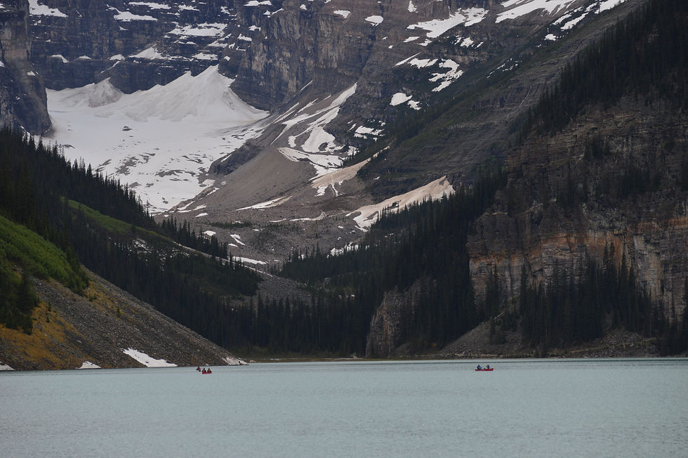
Lake Louise. A body of water with amazing colors and surrounded by forests. There are several trails around the lake, and it is worth doing some to escape the hordes of tourists.
Moraine Lake. Further south (about 15 km) we have another amazing lake: Moraine Lake. You can come simply to contemplate it, but again, i is crowded. The best thing is to choose a path that starts from here to enjoy it further away. There is also a long walk, such as the Perren Route to ascend to the Neil Coulgan Hut, which is already in Kootenay NP territory. It takes about 8 hours.
More routes in: https://www.pc.gc.ca/en/pn-np/ab/banff/activ/randonee-hiking/lakelouise
Trans Canada Hwy
The route that connects Lake Louise and the town of Banff is another spectacular scenic highway. Around 60 km that can be done on the national 1 (the Trans Canada Hwy), or better, on the secondary road 1A (Bow Valley Pkwy), which goes in parallel. Once again the road follows a river of glacial waters (Bow river). There are many places to make a stop and some walks. To see wildlife it is better to drive on the secondary road, because there is less noise and animals prefer it (obviously).

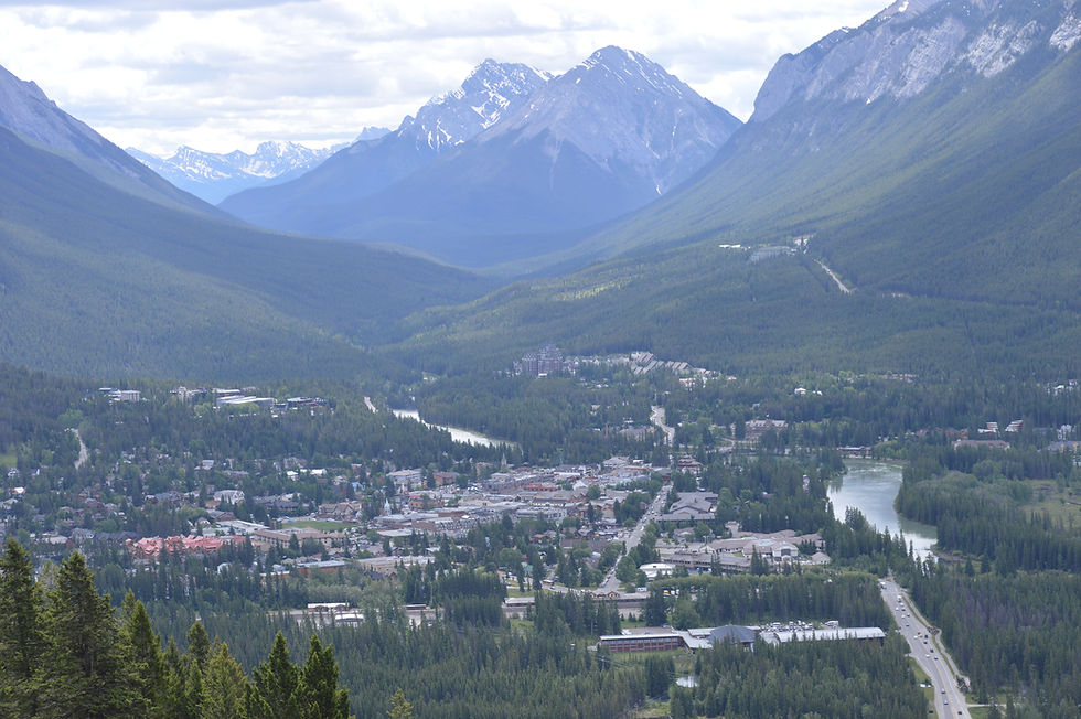
Around Banff
Banff town is in a beautiful setting, surrounded by mountains. It's nice but there are too many people. The best thing resides in its surroundings: you can take a walk (and maybe take a bath?) around the Bow River, "climb" the Mountain Avenue road and get amazing views (and get on a gondola if you fancy), and, of course, you can hike throughout amazing places. Highlights Lake Minnewanka.
Lake Minnewanka. Touristy but spectacular. The farther you walk along the lake, the less people you will find and the more peace in an amazing scenery. Dogs are welcome.

Here are a couple of links with some of the best hikes in the area of Banff and Lake Louise:
https://www.pc.gc.ca/en/pn-np/ab/banff/activ/randonee-hiking/banff https://www.banfflakelouise.com/blog/9-bucket-list-hikes-banff-national-park
YOHO NATIONAL PARK

We continue with the show on the side of British Columbia. Good things come in small packages, and Yoho, being small, is probably the Rocky Mountains National Park that has more attractions per km2... Including amazing routes. Here I leave a more detailed link for those who want to make long excursions: https://10hikes.com/canada/yoho-national-park-hikes/
But best of all is that this Park receives fewer visitors than its cousins in Alberta. The trans Canada hwy leaves behind beautiful mountains, lakes and rivers. Places to stop, coming from east to west:
Lake O’Hara. A crystal clear lake with many trails to do and enjoy the mountains and the views. Take Lake O'Hara Rd (on the left) and travel for about 15 km. I believe all the trails around here accept dogs.
Lower an Upper Spiral Tunnels. Two lookouts that offer very cool views of the mountains... And of the trains that pass through there! Impressive to see these trains circulating on rails that literally fly through the air.
Takakkaw Falls. An impressive waterfall, the second highest in Canada (380 meters). Exit the trans Canada hwy and take a detour to the right, 12 km after the Yoho NP border. At the end of this road (13 km) and after walking 500 meters await this waterfall that will leave you breathless. Dog friendly. Note: the Yoho Valley Road only opens between the end of June and the beginning of October.

Taken from kootenayrockies.com
Iceline trail and Yoho Valley trail. For the more adventurous, these impressive treks await, a loop of 17 km (28 km in the case of the Yoho Valley) that passes through waterfalls, forests... Going up more and more and more, until inhospitable landscapes of glaciers. You need to first pass the Takakkaw falls, until you reach a gravel road to the Whiskey Jack hostel, from where this route officially begins. Look at the differences between both hikes:
Field. For me the most beautiful town in the Rocky Mountains. Very nice, next to a blue glacier river at the foot of a mountain, with Swiss-style wooden buildings, food places and a handful of very cool hotels and cabins. It's worth going through here even if it's not for spend a night.
Emerald Lake. A detour to the right from the trans Canada hwy leads to this stunning lake of the color that its own name indicates. The best thing is that it is much less traveled than other lakes such as Lake Louise or Moraine Lake so you can enjoy it more (besides the chances of seeing wildlife are much greater). A circular path of about 6 km runs along the lake. Those who want to walk more can climb the Emerald basin, from where you get wonderful views of the lake and the mountains. For those who want to treat themselves there is a very cute wooden hotel overlooking the lake. Dogs are welcome :)

Wapta Falls. Other impressive waterfalls. The walk is about 5 km in total and is dog friendly.
All the short hikes: https://www.pc.gc.ca/en/pn-np/bc/yoho/activ/randonnee-hike/courte-short All the long hikes: https://www.pc.gc.ca/en/pn-np/bc/yoho/activ/randonnee-hike/jour-day
BEAVER FOOT FOREST SERVICE ROAD

This service road deviates from the Trans Canada Highway just outside the boundaries of the Yoho NP and takes us to hidden and magical places. Territories that are already outside the Yoho National Park... That is, you will not be in the National Park as such, but it does not matter, because it is all of an amazing beauty... So close to the Park is that, in fact, there is a viewpoint on the same road from which you can see the Wapta Falls. And the best part is that there is nobody in the area, so you can practically enjoy your gift alone. If you like free camping you can sleep with your tent practically anywhere next to the beautiful and powerful river that runs parallel (Kicking Horse river). But, if there is a magical place, that is Marion Lake, a beautiful lake.
GOLDEN

The trans Canada hwy continues to this beautiful town halfway between the Rocky Mountains and the Glacier National Park. Is there a better location? The surroundings are, therefore, a paradise for mountaineers, skiers and fishermen. The village is located on the banks of the Columbia and the Kicking Horse rivers, so you can also do kayaking, rafting, etc. It is very pleasant to walk, both though its streets and the river area. There is a campground by the river (Golden Municipal Campground), but you can also do wild camping in the mountains.
GLACIER NATIONAL PARK

And following the trans Canada hwy, after passing amazing mountains you reach another National Park. The Glacier National Park stretches on both sides of Highway 1 in the Selkirk Mountains, above the Rogers Pass. That is to say, we are no longer in the mountain range of the Rocky Mountains, but in its neighbor. The majority of visitors cross this scenic route slowly, enjoying its landscapes of snow-capped peaks, forests and lakes. And getting out of the car to do some small excursion. There are two very popular routes, due to their ease:
Bear Creek Falls trail. A path of about 4 or 5 km that ends in a river (Bear Creek) ... And in a wonderful waterfall. Dogs welcome to this trail.

Hemlock Grove Boardwalk trail (Giant Cedars). A set of walkways with explanatory panels, which takes you through unique rainforests in the world. Enabled for people with reduced mobility. It's short (350-400 m) and there are a lot of people, but it's worth it.
But there are up to 20 trekking routes in the Park, some multi-day routes, such as the Beaver Valley or the Bald Hills. Here is the official page if you want to have a look: https://www.pc.gc.ca/en/home/pn-np/bc/glacier/activ/randonee-hiking
REVELSTOKE AND MT REVELSTOKE NATIONAL PARK

Just 50 km from the exit of Glacier NP lies this beautiful and interesting village called Revelstoke, which is the base for exploring the Mt Revelstoke National Park. Apart from being embedded in a valley surrounded by giant mountains, on the banks of the Columbiar river, the town itself has a special charm, with very well-kept streets and buildings, as well as several parks. The fans of the trains are in luck, because they can also visit the Revelstoke Railway Museum. If you drive south you'll find fantastic places full of water, like the Arrow Lakes Provincial Park.
But the main attraction is in the north, next to the town. The ascent to Mt Revelstoke is a scenic route (another one for the collection), which offers viewpoints every few kilometers and some fantastic routes. The most beautiful part of this Park, apart from the views, are those meadows full of wild flowers. Come and discover them. The Park is small, with a day or two it should be enough, unless you want to make several long routes. Official website with all routes: https://www.pc.gc.ca/en/pn-np/bc/revelstoke/activ/randonee-hiking
KELOWNA

Taken from kelowna.ca
The city as such is not something of another world, but the area, the Okanagan Valley, is famous for its dry and sunny weather so unusual in Canada... And for its vineyards. Much of the Canadian wine comes from here, and I must say it is surprisingly good (and I am from Spain!). Here, therefore, dry landscapes and communities on the shores of lakes prevail. Although coming from the Rocky Mountains this may seem unimpressive, if you have a few extra days you can come here to do outdoor activities such as boating and water sports, hiking... And visit some winery to try these wines (there are agencies that offer tours).


_edited.png)


